 |
 |
 Opatija Riviera Opatija Riviera
 Rijeka and surroundings Rijeka and surroundings
 > Crikvenica Riviera > Crikvenica Riviera
 Novi Vinodolski Riviera Novi Vinodolski Riviera
 Island of Lošinj Island of Lošinj
 Island of
Krk Island of
Krk
 Island of
Cres Island of
Cres
 Island of
Rab Island of
Rab
 Gorski
kotar Gorski
kotar


|
 |
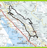
HINTERLAND OF THE CRIKVENICA RIVIERA
In Crikvenica, we depart from the Tourist Bureau, i.e. the Hotel Internacional, and go straight in the direction of Grižane-Tribalj. After 2.2
km, we arrive at a crossroads and turn right toward Grižane. At 6.0 km, we turn left, pass through Franovići (6.2 km), and at 6.6 km turn
left again in the direction of Grižane (7.1 km). After passing through Grižane, we arrive at a dry spring (8.7 km), where we turn right in the
direction of Baretići. After 9.8 km, we continue straight and arrive in Antonovo (10.0 km). Here, at Vele Bašunje (10.3 km), we turn right
and begin climbing a steep narrow road, from which we have a view of Tribaljsko Lake and the island of Krk. At 14.8 km Ñ 660 m above
sea level, we reach a crossroads where we make a full left turn and ascend to a plateau (16.6 km Ñ 780 m above sea level), where we turn
left and begin to descend gradually through a beautiful beech and Mediterranean pine forest. At 23.6 km, we cross a bridge over railroad
tracks and arrive at the Hreljin-Zlobin Road (24.2 km), just before the village of Plase. We turn left on this road, and at 25.2 km we turn left
again on the old Karolinska Road. We descend on a macadam road to Križišće (31.0 km), where we turn left toward Drvenik. We pass
through Drvenik (32.2 km), and below the old town of Drvenik (35.5 km) we enter Tribalj (36.9 km). Along Tribaljsko Lake, we continue
straight toward Semièevići (40.2 km), and arrive at the crossroads (42.5 km) where we turned toward Grižane at the beginning of our
journey. Now, we turn right and return to Crikvenica (45.0 km).
 |
LOCATION: Crikvenica
DEPARTURE: Crikvenica 0 m above sea level
GOAL:
Crikvenica, 0 m above sea level
LENGTH: 45 km
ALTITUDE DIFERENTIAL: 780 m
HIGHEST POINT: 780 m
ACCESSIBILITY BY BICYCLE: TOTAL
DIFFICULTY: DIFFICULT (BLACK)
TIME NEEDED: 3 hours, 30 minutes |

|
 |


